Peace for the World World ! Your War Our Lives

The Dalai Lama
A Brief Colonial History Of Ceylon(SriLanka)
Sri Lanka: One Island Two Nations
A Brief Colonial History Of Ceylon(SriLanka)
Sri Lanka: One Island Two Nations
(Full Story)
Back to 500BC.

Sunday, June 18, 2017
Some questions on floods in south west Sri Lanka

 The
of June 1 gives on Page 14 a discussion of rainfall predictions in the
current season. Talking with an Irrigation Engineer cum Hydrology
specialist, who has also a role in international consultancies, I raised
some questions, which I would like to share, as well as the answers
given by him.
The
of June 1 gives on Page 14 a discussion of rainfall predictions in the
current season. Talking with an Irrigation Engineer cum Hydrology
specialist, who has also a role in international consultancies, I raised
some questions, which I would like to share, as well as the answers
given by him.
2017-06-17
The
of June 1 gives on Page 14 a discussion of rainfall predictions in the
current season. Talking with an Irrigation Engineer cum Hydrology
specialist, who has also a role in international consultancies, I raised
some questions, which I would like to share, as well as the answers
given by him.
This consultant has also worked on the study of water in the Kalutara
District and on the design of the Colombo Katunayake Expressway.
Though he does not wish to give his name his views are well worth
listening to. I have worked with him when we were both Government
functionaries in land and irrigation, he as Irrigation Engineer and I as
District Land Officer, in the early years of our public service.
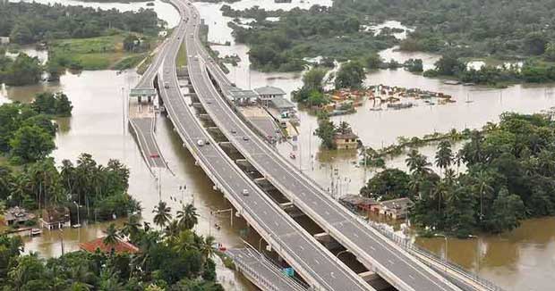
Does it function as a barrier for the flow of water from the interior to the coast and thus cause floods in the interior?
We discussed a question which I raised as to why there was, in the
interior of the Kalutara District, high flooding (Matugama etc.) while
at the same time the coastal area, like the Kalutara town and other
areas a few miles inland did not suffer from it.
I am a Kalutara person (home town etc) and have memories of the lagoon
in front of our home rising and the sand bar being cut to release the
water into the sea. Our own property and its surrounding lands, which
according to survey maps are below the Kalu Ganga flood levels and were
inundated readily, were not affected this year but lands in the
interior, a few miles to the east were under water.
My driver is from Matugama, born and bred, and even in the last couple of years he was expressing surprise that certain parts of the Matugama town and adjoining areas which, in his memory, were normally not flooded, were subject to heavy flooding.
My driver is from Matugama, born and bred, and even in the last couple of years he was expressing surprise that certain parts of the Matugama town and adjoining areas which, in his memory, were normally not flooded, were subject to heavy flooding.
Is there enough space in the culverts or are there enough culverts to take the water across to the sea, in whatever way?
My engineer friend (Let’s call him GM) however pointed to the extremely
high volumes of rains in recent years as evidenced by the rainfall
forecast for April, May, June 2017 as shown on Page 14 of the of June 1
2017, presented by Kelum Bandara, journalist, from an interview with
someone in the Meteorology Department.
GM said that these figures, depicting the intensity of the rainfall,
were more than adequate explanation for the severe inundation of the
interior of the Colombo, Kalutara, Galle and Matara districts.
Rainfall forecast for April, May and June 2017 ( 1 June P 14)
AVERAGE RAINFALL (mm) Kalutara 1233 Galle 1019 Matara 763 Hambantota 245, Colombo 942 Ratnapura 939, Kegalle 1,142 (selected data for western / southern area of SL from table).
AVERAGE RAINFALL (mm) Kalutara 1233 Galle 1019 Matara 763 Hambantota 245, Colombo 942 Ratnapura 939, Kegalle 1,142 (selected data for western / southern area of SL from table).
Without making too much of a fuss however I am tempted to propose a
further question. How come then that the coastal areas of these
districts were relatively free of flooding?
As a tentative answer worth talking about may I bring up the existence
of the Southern Expressway, which is in existence only for a couple of
years. Does it function as a barrier for the flow of water from the
interior to the coast and thus cause floods in the interior?
The raised earthworks and concrete works of the Expressway, running
parallel to the coast 10 TO 20 MILES INLAND can also be seen as a dam
blocking the easy flow of water from east to west in the south-western
area of the country. And thereby causing floods. Another aspect of the
Southern Expressway is that it runs through developed lands such as
rubber, tea and other plantations, located more often than not on
slopes.
The Expressway track runs along the bottom of the land, often, in its
course i.e. in a ravine where the water will collect anyway. Because of
this the water will fill up alongside (unless there are enough culverts
to take it to the other side). But since on the other side too there is
an upward slope the water will collect so that the Expressway will be a
kind of long dry road sitting on top of a water body running north
south, separating the coast from the interior. This is an observation
made by another engineer friend. Is this a true description?
Thus to repeat the point of view: The raised earth and concrete works of
the Expressway, running parallel to the coast 5/10 TO 20 MILES INLAND
can also be seen as a dam blocking the easy flow of water from east to
west in the south-western area of the country and thereby causing
floods. That is the general question. It can be broken up into further
details: Are there sufficient culverts at the bottom of the highway for
water to go under the highway from east to west? If not, the blocking of
water will contribute in a major way to creating floods in the interior
of the south west.
Is it possible to create more space for the water to pass through? If
the answer to the previous question is “Yes” then how can it be done and
how much will it cost and what are the implications?
In contrast to the experience of the Southern Expressway the Colombo Katunayake Expressway has within the short period of its existence not caused problems.
In contrast to the experience of the Southern Expressway the Colombo Katunayake Expressway has within the short period of its existence not caused problems.
But at the initial stages, when the sand foundation was being created
south-north there was an event in Ja-ela which raised an issue. There
was an existing watercourse running east-west taking water to the lagoon
and the sea.
When the sand/earth bar was being created north-south, as a raised
platform for the highway, there was sufficient room left for the water
course to function, taking the water across the course of the sand bar.
Despite this, when the rains came there were unprecedented floods in
that area, though room had been left for the existing watercourse. It
was then clear that water moved not only along the watercourse but
around it too towards the sea and this caused a flood even before the
road itself was built.
The residents of the area created a stir and either for this reason or
whatever the project was abandoned by the then President Chandrika
Kumaratunga. It was taken up later after a lapse of many years and now
functions well. It’s very likely that it was redesigned with the earlier
experience in mind.
This experience may be relevant to the current happenings in the south
west. Is there enough space in the culverts or are there enough culverts
to take the water across to the sea, in whatever way?
My friend tells me that the intensity of the current rainfall could never have been anticipated when the infrastructure was designed. These are outliers. Was this inability to use info about the local scene due to the haste with which it was constructed?
My friend tells me that the intensity of the current rainfall could never have been anticipated when the infrastructure was designed. These are outliers. Was this inability to use info about the local scene due to the haste with which it was constructed?
What was the status of interaction between the foreign contractors and the local expertise?
Lots of questions to ask about the past with the hope of making room for
the future. Are these pertinent questions to ask before more
Expressways are given as contracts to foreign companies without local
inputs and collaboration?
Can one excuse such outcomes as the interior flooding found in the southwest as being caused by unprecedented rains?
Surely we have records going back a hundred years.