Peace for the World World ! Your War Our Lives

The Dalai Lama
A Brief Colonial History Of Ceylon(SriLanka)
Sri Lanka: One Island Two Nations
A Brief Colonial History Of Ceylon(SriLanka)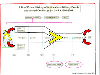
Sri Lanka: One Island Two Nations
(Full Story)
Back to 500BC.
Sunday, November 6, 2016
Palestinians craft first aerial map of refugee camp
Using balloons and a camera, Palestinian refugees have been working on a detailed map of Lebanon's Burj al-Shamali camp.
![Project organisers say it will be the first locally made map of a Palestinian refugee camp in Lebanon [Courtesy Greening Bourj al-Shamali]](http://www.aljazeera.com/mritems/imagecache/mbdxxlarge/mritems/Images/2016/10/23/df635143d9d845e38049b30132e9c0b9_18.jpg)
 BY Jillian Kestler-D'Amours-05 Nov 2016
Burj al-Shamali refugee camp, Lebanon - Amal Said and
Mustapha Dakhloul expertly wind their way through the maze-like streets
of Burj al-Shamali, squeezing through the refugee camp's narrow
alleyways past local children playing on the cracked pavement.
"This was one of the spots," says Dakhloul, 18, looking out over the
refugee camp after ascending a metal ladder to the rooftop of a
residential building, past racks of drying clothes.
Despite their young age, Dakhloul and Said, 20, are making history in
Burj al-Shamali: They have completed several weeks of aerial mapping
using a low-cost digital camera and helium-filled balloon flying high
above the camp.
With the photos, they hope to craft the first ever detailed map of Burj al-Shamali.
 |
| Participants watch from below as the red balloon sails above a spot in the camp [Courtesy of Greening Bourj al-Shamali] |
The project's organisers - including another young participant from the
camp, 19-year-old Firas Ismail - say it will also be the first locally
made map of a Palestinian refugee camp in Lebanon.
"I was very excited," Said told Al Jazeera, noting that the group
started out with around 10 participants, but shrunk to only three in the
end. "It was very hard work."
A bright red balloon was affixed to a light but sturdy string, and
slowly raised to more than 200 metres above the camp. A camera was tied
to the balloon, and it took between 3,000 and 5,000 images from each
spot, Dakhloul said.
It was not always easy: Electricity wires hang precariously overhead in
many areas of the camp, making raising the balloon impossible in some
places. The narrow streets also posed a challenge, as the large balloon
simply could not fit between the buildings.
 |
| The view from the rooftop in Burj al-Shamali [Jillian Kestler-D'Amours/Al Jazeera] |
Bored teenagers in the camp shot the balloon down once, while Lebanese
security officials confiscated the camera's memory card after the group
drew their suspicion when flying the balloon just outside the borders of
the camp.
Depending on the location, the team sent the balloon into the air from
the ground or from rooftops. They chose the balloon because it was the
cheapest option, and gave them a better chance to interact with camp
residents along the way.
According to Said, the map aims to help residents to see where free
space exists to build parks or play areas for children, or to plant
vegetables or plants with medicinal purposes on rooftops.
"When people look at the map, they will see where the important areas
are," she said. "Every person who sees the map can also draw their own
idea from it … about how we can benefit."
 |
| Mustapha Dakhloul, left, and Amal Said on a rooftop in Burj al-Shamali, one of the spots from which they flew a balloon over the camp [Jillian Kestler-D'Amours/Al Jazeera] |
Three kilometres east of Tyre, in southern Lebanon, Burj al-Shamali was
built in 1948 to house Palestinian refugees from the Hawla and Tiberias
areas of northern Palestine in tents. In 1955, the United Nations agency
for Palestinian refugees began providing services to residents in the
camp, who had gradually built concrete and tin structures.
Today, Burj al-Shamali is home to almost 25,000 Palestinian refugees.
Mahmoud al-Joumma, president of the camp's branch of the youth support
group, Beit Atfal Assumoud, said that children and camp residents had
been running after the mapping group, curious because they had never
seen balloon mapping before. "In the beginning, really, I didn't believe
it was possible," Joumma told Al Jazeera about his own initial reaction
to the project.
But he said that holding a physical map in their hands might help to
change the fact that many residents in the camp do not fully understand
the conditions in which they are living, and the challenges the
community faces.
We understand our situation, our difficult conditions inside the camps,
but we believe that even if there are difficulties, there is the
possibility to [build] for the future, to give a future to [the youth]."
"Some people know their home, here," he said, "but they didn't know
exactly what they would find on the other side [of the camp], how life
is on the other side."
He explained that unemployment and poor educational opportunities are
major concerns in Burj al-Shamali, but the project is a clear example of
how solutions are possible.
"It's just to encourage our youth," Joumma said. "We understand our
situation, our difficult conditions inside the camps, but we believe
that even if there are difficulties, there is the possibility to [build]
for the future, to give a future to [the youth]."
When it is finished, the map will mark services in Burj al-Shamali -
health and dental clinics, schools, mosques, and local organisations -
as well as important points on the main road, which makes a circular
loop around the entire camp, Joumma said.
It will also include the demarcations of different neighbourhoods, which
remain named after the villages in historic Palestine from where the
refugees originally hailed. "Every region in the camp has a name … Here
Hatoum, here Safouri, here Al-Naima, here Ez-Zouk," he said.
The project is now in the final stage, and organisers are raising money
to print the maps and distribute them among residents, government
officials, human rights groups and humanitarian groups in Lebanon, among
others.
They also hope to send the three Burj al-Shamali youth
map-makers - Said, Dakhloul and Ismail - to the United States to meet US
mapping experts and speak to groups about their experiences.
But according to Claudia Martinez Mansell, coordinator of the Greening
Bourj al-Shamali project, their US visa applications were recently
rejected on the basis that they could not prove sufficient ties to
Lebanon.
Consular officials reportedly said this could be proven by showing
marriage certificates, job contracts or property ownership certificates -
"all impossible things to ask 18-, 19- and 20-year-olds who are still
at university", Martinez Mansell said, noting that they would apply for
the visas again.
"I have not given up," Martinez Mansell said. "To me it is so important
that they get the opportunities to learn and be recognised for their
work, so that they can come back and carry out the work they are doing."

An aerial view over Burj al-Shamali camp taken with the balloon mapping technique [Courtesy of Greening Bourj al-Shamali]