Peace for the World World ! Your War Our Lives

The Dalai Lama
A Brief Colonial History Of Ceylon(SriLanka)
Sri Lanka: One Island Two Nations
A Brief Colonial History Of Ceylon(SriLanka)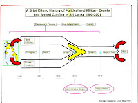
Sri Lanka: One Island Two Nations
(Full Story)
Back to 500BC.

Tuesday, May 30, 2017
How long will the destructive development going to continue ?


 May 29, 2017
A
large number of people have died due to the current disaster situation.
Many lost their homes. A mass destruction resurfaced. This is not the
end but the beginning. A few years ago Meeriyabedda faced a massive
landslide and many lives were lost. It was proven without any doubt it
is a result of the Uma Oya project and nothing to do with climate change
or god’s will.
Yet, the authorities blamed the climate change. Climate change is like
the god. When authorities fail to take the responsibility and when it is
difficult to understand reasons behind the catastrophe, they blame the
god. Climate change is a cover up for the world’s thuggery. It is like
the hypothetical god who is not there to physically take the
responsibility. The so called leaders have cleared their names by
blaming the climate change for floods, landslides and every possible
natural disaster. But, in actual sense, this is the result of the so
called development taking place in our country. Even the public does not
remember the environment until a disaster happens. They allow the
rulers to destroy the nature according to their desire.
The 103 valleys along the rivers of Sri Lanka has already started to
face the adverse consequences. To every river there are natural ponds
and water absorbing buffer zones. Along most rivers this land has been
used for development or houses are constructed. When these low lands are
blocked with these constructions the result is flooding – inundating
the whole area. This is nothing but collective effort of stupidity.
The marshy lands long the Kelani River, almost all being filled and
developed. Muthurajawela, the lowland that allows the water to flow to
the sea is being blocked by the highway construction. According to the
directives of the World Bank, being greedy to the monetary commissions,
highways are built in Sri Lanka unlike in any other country. Even in
India, highways, when constructed near sensitive environment areas are
built on pillars to minimize damage. Yet, in Sri Lanka highways were
constructed across Muthurajawela and several other different areas
building a barrier filled with 240,000 cubic meters of sand and soil per
kilometer. When the natural drainages are blocked like this it is not a
surprise that the center of the country getting flooded.
This barrier obstructs natural water drainage up to Matara as the
highway runs towards Matara. And as highways are built around the
country, it will block the water drainage further all over the country.
As a result these highways will act like barriers blocking the water
that gets collected during the rains from naturally draining to the sea.
By observing the flood situation in areas like Kaduwela and Ja Ela this
can be understood very well.
These landsides are nothing natural but adverse results of unplanned
mega development. The Central Hills and the peripheral mountains act as
water storage. Retaining the needed amount, the balance water gets
naturally released to other water ways. When these water ways are
blocked, the excess water gets adsorbed creating a lining between the
soil particles and as a result the soil is loosened. Thus creating a
landslide. This has less connection to climate change but more to human
activities that block the waterways that carry the excess water.
Constructing mega and mini hydro power plants in the Central hills,
deforestation and digging tunnels detach the surface rocks from the
mother rock. These landslides will not end with those that happened in
Meeriyabedda, Aranayake and Nikolaya. It is scientifically proven that
this can happen anywhere, where this kind of human activity happen.
Aggravating the destruction highways are built up. These are not just
within the country but would extend even to Dhanushkody in India,
linking the Sri Lankan highways with the Asian highways. The process
does not end here. There will be expressways linking cities creating a
network of highways within the country. And all these highways will be
built mounting sand and soil in the shape of a dam. The proposed
railway network will add to the misery.
In addition the plan to develop Sri Lanka as a multi-faceted tourism
area, where one section for hotels, another for eco tourism along the
beach, the sea and different eco systems, will be another destruction.
Under this there will be zones developed from Chilaw towards the North
and the South, Anuradhapura, Polonnaruwa, forest areas such as Bibile
and Nilgala and in many more.
The
plan to make Sri Lanka an aviation hub in 2030, a keen desire by China,
India and America, will also result in expanding the Katunayake
airport. In addition to Mattala plans are underway to develop another
International Airport in Hingurakgoda.
Airports in Palali, Trincomalee. Puttalam, Batticaloa, Kalutara,
Vavuniya, Anuradhapura, Galle, Ratmalana will be developed further and
since 2013 plans are underway to develop two airports in Nuwara Eliya
and Dambulla. Eventually there will be 19 airports in Sri Lanka.
According to the National Physical plan selected areas in Anuradhapura,
the North and in Moneragala will be developed as agriculture areas at
industrial level growing fruits, vegetables, peanuts, palm oil and
valued timber. The Government is interested in inviting more investors
to build factories in many other places.
Megapolis areas are planned centering main cities and in addition
several other areas will be developed as main city centers, special
cities and District capitals creating industrial cities, investment
zones and IT hubs. These areas will include the stretch of cities from
Gampaha to Kalutara, from Matara to Thanamalwila (megapolis), from
Ampara to Batticaloa covering the East (main cities). The North Central
mega city will be around Anuradhapura, Polonnaruwa, Dambulla and
Trincomalee. Jaffna mega city will be around Mannar, Killinochchi to
Point Pedro.
Following are the number of people the Government plan to settle in these developed cities –
Western Megapolis – 3.5 Million
Southern Megapolis – 01 million
Galle main city – 01 million
Eastern Megapolis – 01 million
North Central Megapolis – 04 million
Jaffna mega city – 01 million
According to the plan people living in hazard prone areas will be settled.
The coast line will be heavily industrialised with nuclear power plants
and hydro power plants and with the development of the fisheries
industry the number of boats will be increased to 40,000. Facilitating
the fisheries sector , from Batticaloa to Hambantota a fiber
communication network will be created through Lahugala, Yala and
Udawalawa forest reserves and wildlife parks.
In such a back drop how would it be possible to save people from floods
or droughts? As the floods recede the importance of strategic
development and environment protection will drain. People will act dumb
allowing the rulers to destroy the nature. As long as people do not get
actively involved this problem will never find a sustainable solution.
It is they who will pay the price with their lives.
Ravindra Kariyawasam
Centre for Environment and Nature Studies